
|
|||||||||||||
2023 had without question the most prolific storm season I've ever witnessed. Many of my personal records were broken for prolific thunder, the number of storms encountered, their high caliber, huge CAPE values and their magnificent beauty. In fact, on one particular day I witnessed two multicell storms which I consider to be the most spectacular cells I've ever experienced in 26 years of chasing. The updraught plumes were spectacular, we even had an MCS with 3000j/kg of CAPE, twilight lightning, and broken temperature records. The year was also complimented by beautiful snow scenes, the tallest sunpillar I've ever observed, two beautiful G3 geomagnetic storms with extremely rare STEVE and SARs phenomena. This was a year of countless adventures and road trips which I will always cherish.
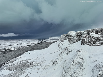
A new year of storm chasing and night sky photography has begun, this first account of 2023 documents two Winter convective chases. The first on Jan 15th at Benone beach where we documented a photogenic Cumulonimbus cell and the second on Jan 17th during a day of heavy shower showers and 400 CAPE with -40c cloud tops. This was a challenging day battling low cloud and relentless snow showers, I almost never got an image until a sudden break before sunset when I got the new Mavic 3 Classic drone in the air and filmed Binevenagh covered in a quilt of snow with cloud scudding across the summit. This dramatic scene made the chase for me. One page report with 10 images and 1 video clip. - REPORT. |
 |
| I never would have thought that February 2023 would produce the best planet conjunction since 2012 and best aurora since 2014 all within the same week. This report covers a beautiful triple conjunction between Venus, Moon and Jupiter from Beaghmore on the 22nd followed by a stunning G3 geomagnetic storm on the 26th when two CMEs impacted Earth's magnetic field with solar wind speeds over 700km/sec and a Bz of -17. I chased to Ballintoy on the north coast then back inland to experience a beautiful outburst with friends at the wind farm near Swatragh. On show was a twin tiered arc and red beams 50 degrees high which made for the best aurora experience in nine years. One page report with 13 images and 2 time lapse videos. - REPORT. | 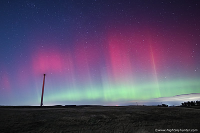 |
| I thought my chances of getting more snow scenes this season were gone until the models presented a potent cold spell on the way for N. Ireland. On March 9th a warm front interacting with Polar air would produce a notable frontal snow event with amber warnings from the Met Office. I was up early on March 10th to take advantage of the frontal clearance. We began on Benbradagh then made our way to Slemish mountain in Ballymena which was the highlight of the chase with perfect sunshine and blue skies in a Winter wonderland. I've always wanted to film this extinct volcano in snow and on this day I made it happen. One page report with 20 images and 2 video clips. - REPORT. | 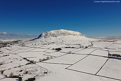 |
| March 2023 has turned out be the most impressive start to a storm season I've ever seen with numerous high caliber convective outlooks issued for Ireland and N. Ireland. This report covers several chase days however the highlight took place on the 29th with strong 0-6km shear, 40knots DLS on a warm SWly Summer-style flow with 500-800j/kg of CAPE, TORRO had addressed a tornado and splitting supercell risk. Sheared cells fired rapidly behind the front and by mid afternoon I was at Ballyronan Marina watching these cells crossing the lough. The second cell stole the show exhibiting all the visual hallmarks of an LP supercell with the most solid sheared anvil I've ever seen in March, the cell also boasted a hook echo on radar which made for a very interesting early season chase day. One page report with 15 images and one video clip. - REPORT. |  |
| The Spring 2023 convective season is well underway with statistics showing a marked increase in activity in comparison to recent years. This report documents several local chases hunting for funnel clouds, busts, and the quest to find storm structure. The highlight was April 30th with the greatest instability of the year yielding + 1000j/kg of CAPE and a MO yellow warning. My Wife and I spent the day chasing and after having doubts about messy clouds and lack of shear the tables turned when several thunderstorms fired in the vicinity of Lough Neagh. The main storm of the day surged over Ballyronan Marina with torrential rainfall, thunder/lightning, and sported a mean chunky gust front which I captured by drone making this the first structure day of the season. One page report with 12 images and 1 video clip. - REPORT. | 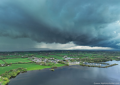 |
| With CAPE values in excess of 1000j/kg and -50c cloud tops with Cz zones overlapped by 20 knots DLS this looked to be the best chase day of the season. The day began warm and humid, capping looked to be an issue but not wanting to give up my friends and I relocated to a convergence zone outside Ballymena in Co. Antrim. After a very long wait the cap suddenly broke during the evening hours thanks to an approaching cold front. We got treated to a mean dark blue multicell storm line which rumbled menacingly over scenic fields and an isolated farm house. The storm produced dangerous positive c-g bolts which were the closest strikes we have experienced for many years, this lightning also damaged property in the area. A thrilling storm and a real emotional roller coaster ride of a day, this single chase made the month of May. One page report with 13 images and 1 video clip. - REPORT. | 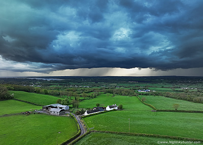 |
| On May 29th in the midst of an outstanding HP weather pattern I got a message from a mate alerting me to the presence of a spectacular sunpillar above the setting sun. With no time to waste I got the drone in the air for a look, then as the sun began setting over the Sperrins an unusual 'cross' formation appeared within the pillar, it was a most unusual sight and something I've never seen in 25 years of sky watching. A wonderful surprise optics display to end a stunning warm day, watch the drone footage as I zoom into the cross. One page report with 7 images and 1 video clip. - REPORT. | 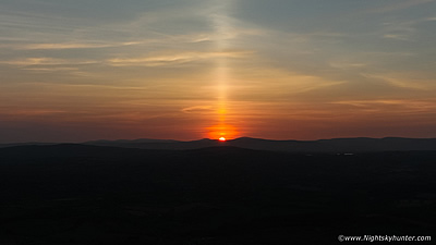 |
| June 13th was the biggest set-up of the year with surface based CAPE values of 3000j/kg with a threat of frequent lightning, 3cm hail and an MCS forming during a very humid heat wave. We chased to Mullaghmore in Co. Sligo on the west coast of Ireland and by evening time intercepted a huge Mesoscale Convective System which emerged from the heat haze like a monster. The storm surged over with very active lightning and the first proper rain in four weeks. This MCS boasted an anvil almost the size of Ireland, tops of 36,000ft with upper temps at -60 degrees C, a remarkable long lived storm which had been producing lightning for more than six hours. Also included is a scenic sunset with wind turbines from Omagh. One page report with 8 images and 1 video clip. - REPORT. | 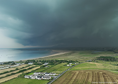 |
| June 17th was the beginning of a major thunderstorm outbreak across Ireland in the midst of heat wave conditions. For the second time a team of us chased to Mullaghmore in Co. Sligo on an adventure to intercept 2000j/kg severe thunderstorms and we were not disappointed. For much of the day we where surrounded by high based highly electrified storms, at times with three active cells around us at any given moment. We heard more thunder this day than the last few years combined. At dusk a surprise elevated storm moved over Kesh where we got our best images of the day of c-g bolts striking the surface over this scenic landscape. One page report with 12 images and 1 video vlog. - REPORT. | 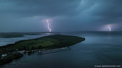 |
| June 3rd was my third trip to Mullaghmore in Co. Sligo and the second back to back chase in this area where yet again high humidity and 1700j/kg of CAPE would result in big thunderstorms. I went chasing with my Wife Roisin and after hours of glorious sunshine and a strong cap the atmosphere erupted in the evening time over W Ireland. We got treated to four thunderstorms, three of which were in fairly close range. The highlight were two very strong cells over the ocean and Co. Donegal which sported nice structure in the form of anvils, updraught tops and a beefy shelf cloud as thunder rumbled in the background. For the third chase in a row this region produced yet again. One page report with 10 images and 1 video vlog. - REPORT. | 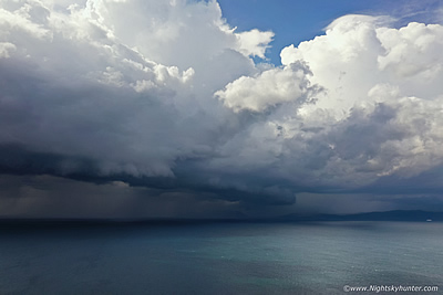 |
| Part 1 of what I consider to be the most spectacular thunderstorm convection I've ever seen in this country on June 19th during my fourth storm chase in a row. This was the hottest June on record and the most thundery period Ireland has seen for many years. With 1000j/kg of CAPE and 20 knots DLS multicell storms were anticipated. On this solo chase I headed to the north coast and committed to that target area for the day, at first I wasn't impressed with the rubbish skies and pulse cells I was seeing, I almost went home. Suddenly during the late evening the cap broke which resulted in two remarkable thunderstorms which erupted like atmospheric volcanoes with enormous tops and stunning updraught convection. These were the most beautiful thunderstorms we had ever seen in our lives and of a caliber rarely seen in N. Ireland. One page report with 23 images. - REPORT. | 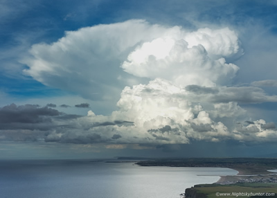 |
| Part 2 of what I consider to be the most spectacular thunderstorm convection I've ever seen in this country on June 19th during my fourth storm chase in a row. This was the hottest June on record and the most thundery period Ireland has seen for many years. With 1000j/kg of CAPE and 20 knots DLS multicell storms were anticipated. On this solo chase I headed to the north coast and committed to that target area for the day, at first I wasn't impressed with the rubbish skies and pulse cells I was seeing, I almost went home. Suddenly during the late evening the cap broke which resulted in two remarkable thunderstorms which erupted like atmospheric volcanoes with enormous tops and stunning updraught convection. These were the most beautiful thunderstorms we had ever seen in our lives and of a caliber rarely seen in N. Ireland. One page report with 16 images. - REPORT. |
 |
| The impressive 2023 thunderstorm season continues with yet another chase for the fifth day in a row on June 20th when an unstable humid air mass with 1500j/kg of CAPE was expected to produce strong thunderstorms with flooding potential. After watching morning developments on radar and anticipating an area of interest moving into the Mid-Ulster area by late afternoon I drove to the Beaghmore region of the Sperrins to watch convection. By mid afternoon I encountered not one but three active thunderstorms from my position on the scenic route outside Cookstown. I had the privilege of watching several beautiful storms in full sunshine rumbling away over the tranquil countryside at close range with one cell having a very nice updraught base. This was followed by a convective line intercept out the Coagh Rd which made for a fun local chase. One page report with 13 images and 1 video vlog. - REPORT. | 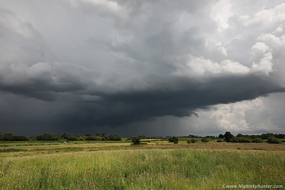 |
| On June 25th 2023 another warm humid unstable airmass moved across N. Ireland with 800j/kg of CAPE and sufficient wind shear for multicell thunderstorms on what would be my 6th storm chase within the current thunderstorm outbreak. This time the E of the country looked best so my Wife and I drove to the beautiful Slemish Mountain near Ballymena where we met Colleen Webb and Nigel McFarland. By mid afternoon a striking Cz produced a line of convection which grew into a dramatic rotating base which dropped a funnel cloud, above this was a remarkable rock solid updraught. By evening another big multicell storm moved in with core turning parts of the country white with hail, this mean black storm had more spectacular updraught plumes. A great day out with impressive cloudscapes over beautiful countryside. One page report with 25 images and 1 video vlog. - REPORT. | 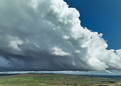 |
| July 9th brought to an end our exceptional Summer thundery period and it did so in style. Despite no shear there were substantial CAPE values with strong heating and convergence zones. Roisin and I spent the day chasing, a quiet afternoon made us think the cap at suppressed activity, then a few hours later we were caught off guard when an intense thunderstorm developed over Co. Tyrone and Sperrins. We watched the storm pass over Slieve Gallion and Straw with regular thunder and a nice gust front. Another late evening storm was intercepted over the Cookstown carriageway followed by two more storms which in combination delivered over four hours of thunder in this area. The evening ended with a 9pm mammatus display with two regions of lightning flashing at the same time. One page report with 15 images and 1 video clip. - REPORT. | 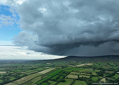 |
| I thought Summer was over, then suddenly we had a return to warm humid weather when a Sly plume with Saharan dust brought temps to 25c and above for days marking a welcome heatwave event. Sept 7th was extremely unstable with 2000 CAPE and strong shear, as a result a severe thunderstorm watch was issued. On this unforgettable day I experienced rare continuous thunder unlike anything I had ever experienced before in my life from elevated storms over Cookstown. I experienced 7-8 thunderstorms and four hours of thunder over the same area making this the most active Sept storm event I've ever experienced. Although not a photogenic day the audio experience was unforgettable! One page report 5 with images and 1 video clip. - REPORT. | 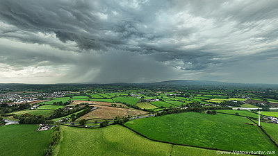 |
| Friday Sept 8th was a day with explosive potential with CAPE associated with a heat wave plume remaining inland into the early night. The atmosphere was strongly capped but by late evening temps peaked at a record high of 28 degrees C, the cap broke and an isolated multicell erupted to life in the sunset sky. As twilight deepened the W sky was dominated by this beautiful isolated storm over the Sperrins with dark updraughts lit from within by intra cloud lightning. I even captured six cloud to air bolts shooting into clear sky from the flanking updraught plume. Roisin and I watched this rare event with awe on the most warmest humid Sept night we had ever experienced. One page report with 20 images and 1 drone video. - REPORT. | 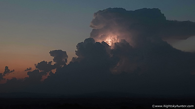 |
| Sept 10th was the third thunderstorm day within four days over this weekend thanks to an unstable Sly HP plume event which introduced 600-1000 CAPE overlapped with 20 knots of deep layer shear. The set-up was notable for a marked surface trough and very well defined convergence zone which promised convective action across the Sperrins. During the late afternoon of a very warm and humid day the cap broke and a cluster of multicell storms erupted over the W of Mid-Ulster crossing the Sperrins. I chased to the iconic stone circles at Beaghmore with John Fagan and intercepted a large black storm rumbling over the hills for over an hour and a half. The storm then formed a shelf cloud which passed directly over the famous stone circles in lovely evening light which made for a dramatic end to the day. One page report with 17 images and 1 video clip. - REPORT. | 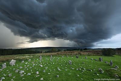 |
| On October 11th 2023 a surprise visitor arrived on Lough Foyle in the form of a cruise ship called Norwegian Star. At 294m in length this fifteen deck ship was not only the largest cruise ship ever to grace the Foyle but she was also the largest ship ever in history on these waters. As a ship lover I spent the day in Co. Donegal filming her inbound passage at 07.00 and outbound passage at 16.00, however it was the pre-dawn session which really was an unforgettable experience. The Norwegian Star arrived in the semi dark pre-dawn sky lit-up with golden lights like a floating hotel which made for a spectacular drone flight and the perfect way to experience Lough Foyle history first hand. 14 images and 1 video clip. - REPORT. |  |
| On November 5th 2023 three CMEs impacted Earth with two of them back to back within an hour of each other. The result was a strong solar storm with a BZ of -30 which would peak at G3 (KP7) making it one of the strongest storms of the current solar cycle. After an intense 6 hour wait during daylight and a chess game studying the weather to avoid advancing cloud I decided to head E and watch the event from the wind turbines at Swatragh with Conor McDonald. As the sky cleared we were astonished to witness a rare phenomena called STEVE pulsating in the E near Jupiter which crossed the entire sky with a red beam called SARs. The aurora went into two outbursts with rays reaching almost overhead with red, orange and green colours to the naked eye. Other friends arrived and we watched with awe as nature put on a splendid show - an amazing night! One page report with 25 images and 1 video clip.- REPORT. | 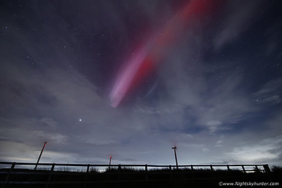 |
'Convective Uprising' is my 2023 sky highlights video covering my favourite moments of what has become my best year of sky action. The year was striking for its surge in convective weather, hence the title. Thunderstorms dominated the atmosphere on a scale not unlike the caliber seen in the Tropics with prolific lightning activity, exceptional CAPE values, storm frequency and their majestic structures and beauty which I consider unsurpassed in all my years of storm chasing. Many personal records were shattered and numerous remarkable memories and atmospheric adventures were forged. The year also seen a dramatic up tick in aurora activity thanks to approaching solar maximum with spectacular rayed G3 storms which yielded extremely rare phenomena in the form of STEVE and SARs.
This video is 30 min's in duration and features a wide range of elemental samples from these adventures. The majority of the footage is captured by drone, specifically the DJI Mavic 3 Classic and DJI Mavic 2 Pro. Time lapse cinematography is also a feature of the video, these were filmed with a Canon 5D Mark IV and Canon 600D with a variety of fast lenses. From the crisp snow scenes of Winter to the hot and humid boiling updraughts of Summer 2023 sets a new bench mark in standards, I hope you enjoy the presentation.
Martin McKenna
